French Niger
Quick reference
General issues: French civil territory 1921-1922, French colony 1922-1944
Country name on general issues: Niger
Currency: 1 Franc = 100 Centimes 1920-1944
Population: 1 781 000 in 1920, 2 168 000 in 1944
Political history French Niger
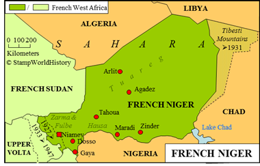
French Niger is located in western Africa – the current Niger. The most important peoples in the country are the Hausa in the south, the Fulbe and Zarma in the west and the Tuareg in the north. As such, Niger is located at an intersection of the ethno-linguistic divisions in Africa: the Hausa and the Tuareg are Afro-Asiatic peoples, the Zarma are a Nilo-Saharan people and the Fulbe are a Niger-Congo people.
In 1885, Niger is awarded to the French at the Berlin conference, where the colonial powers define their respective spheres of influence in Africa. At the time, the French have yet to establish themselves in Niger – they move into Niger in 1890. In 1899, the sultanate of Zinder is conquered and a territory under military administration is defined – the military territory of Zinder. The territory is, at the time, part of Upper Senegal & Middle Niger and, from 1902, from Senegambie & Niger. In 1904, the territory becomes part of Upper Senegal & Niger upon which the name is changed to Niger. In 1911, Niger becomes a separate – still military – territory within the federation of French West Africa – the federation of French possessions in western Africa established in 1895 – reporting directly to the governor general of French West Africa. The French gradually extend direct French rule in Niger, but it will take until the early 1920’s before the Tuareg are finally subjected. French Niger, in 1920, becomes a civil territory and is raised to the status of a French colony in 1922.

Tuareg – How impressive can a picture be ……..
The border of French Niger with British Nigeria is defined through a treaty in 1898. The border with Libya is not formally defined until a treaty is signed with Italy in 1919 – Libya at the time being an Italian possession. The borders with the neighboring countries in the French sphere of influence are adjusted a number of times. In 1927, a border adjustment is effected with Upper Volta. When, in 1933, Upper Volta is dissolved and divided, French Niger gains part of Upper Volta – a part that will be returned to Upper Volta when Upper Volta is re-established in 1944. In 1931, the border with Chad is adjusted when the Tibesti Mountains are transferred to Chad. Thus, the borders of Niger are defined as we know them today. Note: period maps do not concur on the pre 1931 border with Chad – the map in this profile shows an approximation.
French Niger, in 1946, becomes a French overseas territory and, in 1958, gains self government. In 1960 French Niger gains independence as the republic of Niger.
Postal history French Niger

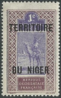
1921 – Upper Senegal & Niger overprinted ‘Territoire du Niger’. The stamp shows a Tuareg camel rider.
The first post offices are opened in French Niger in 1894. The first stamps used are those of French Sudan – these to be followed by the issues of Senegambie & Niger and Upper Senegal & Niger. When French Niger has become a civil territory, stamps are issued for French Niger from 1921. The first set issued are stamps of Upper Senegal & Niger overprinted ‘Territoire du Niger’. The first definitives are issued in 1926. The stamps of French Niger are inscribed ‘Niger’, with the additional inscription ‘Afrique Occidentale Française’ or ‘AOF’ to show that French Niger was part of the federation of French West Africa.
Album pages
← Previous page: French GuineaNext page: French Somali Coast →


