Saint Vincent
British colony

Saint Vincent
Independent
Quick reference
General issues: British colony 1861-1958, Province West Indies Federation 1958-1962, British colony 1962-1969, Associated state 1969-1979, Independent within the British Commonwealth 1979-Present
Country name on general issues: St. Vincent, St. Vincent & the Grenadines
Special issues:
- Regional issues:
- Grenadines of Saint Vincent 1973-1992
- Bequia 1984-Present
- Canouan 1997-Present
- Mayreau 2006-Present
- Mustique 1997-Present
- Palm Island 2003-Present
- Tobago Cays 2003-Present
- Union Island 1984-Present
- Young Island 2006-Present
Currency: 1 Pound = 20 Shilling, 1 Shilling = 12 Pence 1861-1949, 1 Dollar = 100 Cent 1949-Present
Population: 45 000 in 1900, 109 000 in 2013
Political history Saint Vincent
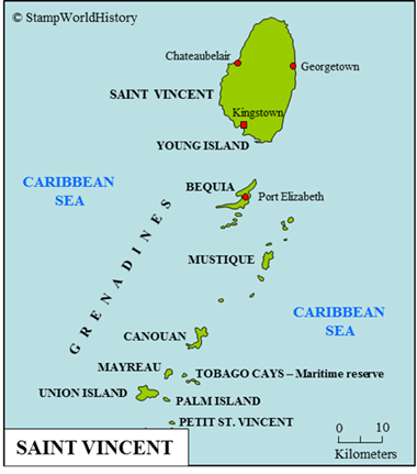
Saint Vincent is an island country located in the Caribbean as part of the Lesser Antilles – for the exact location, please refer to the map of the Caribbean. The full name of the country is Saint Vincent & the Grenadines, reflecting the fact that the country consists of the main island of Saint Vincent and the northern part of the Grenadines – the southern part belonging to Grenada. Prior to colonization, Saint Vincent was inhabited by the Amerindian Carib people – a people found on many of the Lesser Antilles. The first exploration by Europeans – often attributed to Christopher Columbus in 1498 – is unrecorded. The first non-Carib settlers on Saint Vincent were, in the 17th century, slaves who had escaped from neighboring islands or were shipwrecked on Saint Vincent. They intermarried with the Carib, forming a distinct ethnic group – the Black Caribs. From the European nations, competing for possessions of the Lesser Antilles, the British were, also in the 17th century, the first to claim Saint Vincent. The British, however, did not settle the island. The Carib successfully warded off European settlement until the early 18th century, when the French were the first to settle the island. In the course of the 18th century, Saint Vincent would go back and forth between France and Great Britain until the French finally recognized British sovereignty over the islands in 1783. The Carib, however, did not recognize British sovereignty. Carib opposition was finally subdued in 1796 and the Caribs were, subsequently, exiled from Saint Vincent – ultimately to an island off the coast of Honduras from where they spread to different parts of Central America.
Once established as a British colony, Saint Vincent was, in 1833, made part of the Windward Islands colony – the federal colony that grouped together the British possessions in the Windward Islands. The Windward Islands colony was – unlike the Leeward Islands – a loose federation in which the constituent parts had their own parliaments and legislation. The Windward Islands colony was dissolved in 1956. Shortly after, between 1958 and 1962, Saint Vincent joined the West Indies Federation – a short lived federation of most of the British possessions in the Caribbean.

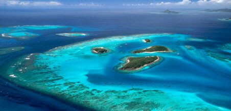
The Tobago Cays are an uninhabited marine reserve in the Grenadines of Saint Vincent – and an entity for which Saint Vincent issues stamps.
In 1967, Saint Vincent became self governing as an associated state, and in 1979 Saint Vincent gained full independence within the British Commonwealth as Saint Vincent & the Grenadines. Thus, Saint Vincent, currently, is a parliamentary democracy with the Queen of Great Britain as head of state.
Economically, Saint Vincent was developed as a plantations colony with coffee, cocoa and – the most important – sugar cane as crops. To man the plantations, slaves were brought to the island who soon outnumbered the planters of European descent. The production of sugar cane declined in the 19th century and in the 20th century bananas became the most important crop. Saint Vincent, currently, is still predominantly an agricultural nation, but tourism is being developed, mainly in the Grenadines. The majority of the population is black – 66% – with a large minority of people from mixed descent – 19%. The Carib account for 2% of the population. Saint Vincent is the main island of the country and is home to the vast majority of the population – 101 000 in 1994. Eight of the Grenadines are inhabited, of which three are resort destinations only – together the Grenadines counted 8 600 inhabitants in 1994.
Postal history Saint Vincent
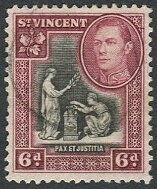
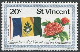
The first stamps used in Saint Vincent were the general issues of Great Britain. These were used between 1858 and 1860. Saint Vincent issued its first stamps in 1861. Until 1898, stamps were issued only of designs specific for Saint Vincent – showing the portrait of Queen Victoria or the seal of Saint Vincent. From 1898, stamps were also issued in designs common to the British colonies. Saint Vincent joined in a number of the omnibus issues for the British colonies. In the modern era, as an associated state, Saint Vincent issued stamps with a blend of themes of national interest and themes aimed at the thematic collectors market. Since independence, the large numbers of stamps issued are almost exclusively aimed at the thematic collectors market.
In addition to the stamps issued for the country of Saint Vincent as a whole, between 1973 and 1992 stamps were issued for the Grenadines of Saint Vincent, and, from different dates starting in 1984, for some of the individual islands in the Grenadines – including the uninhabited maritime reserve of the Tobago Cays and the resort islands Palm Island, Petit St. Vincent, and Young Island.[1]For the individual islands, the Michel catalog has an abbreviated listing, Scott lists a limited number of issues, and Stanley Gibbons lists most issues in the Appendix as stamps that ‘have either been issued in excess of postal needs, or have not been made available to the public in reasonable quantities at face value’.
Jim Jackson, owner of the Big Blue 1840-1940 blog, qualifies Saint Vincent as a country with ‘runaway stamp production’ – and rightfully so. Small though the country may be, based on the stamps issued between 1980 and 2002, Saint Vincent proper ranks third on the list of the countries that issued the most stamps in the world. Interestingly: neighboring Grenada, equally small, ranks seventh on the list.
The statistics , as per the Big Blue 1840-1940 blog, are:[2]The numbers quoted from the Big Blue 1840-1940 blog are based on online resources and will differ from the numbers found in the world wide catalogs most often referred to on this site.
1. Guinea – 8 750
2. Guyana – 7 606
3. Saint Vincent – 6 586
4. Gambia – 6 239
5. Guinea-Bissau – 5 855
6. Mozambique – 5 569
7. Grenada – 5 528
Now, in the statistics as per Big Blue, the Grenadines of Grenada and of Saint Vincent are listed separately as follows:
13. Grenadines of Grenada – 4 410
23. Grenadines of Saint Vincent – 3 153
Should we combine the stamps issued for Saint Vincent and Grenada proper with those issued for the Grenadines for a grand total of these countries, Grenada would top the list with Saint Vincent as a close number two – both well ahead of number three:
1. Grenada & Grenadines – 9 938
2. Saint Vincent & Grenadines – 9 741
3. Guinea – 8 750
4. Guyana – 7 606
5. Gambia – 6 293
For more about ‘runaway stamp production’ – including an analysis of per capita stamp production in the countries discussed – please refer to the St. Vincent page on the Big Blue 1840-1940 blog.
Album pages
← Previous page: Saint LuciaNext page: Saint-Pierre & Miquelon →


